New Interactive Map Helps Carlsbad Residents Identify Major Roads, Intersections and Emergency Resources
Carlsbad residents and visitors now have a new way to better understand the roads, intersections and community resources that shape everyday travel across the city.
A newly developed Carlsbad Personal Injury & Accident Resource Map brings together information about major traffic corridors, intersections identified in local roadway-safety analysis, community destinations and emergency resources in one interactive format.
The resource was developed by HHJ Trial Attorneys as a public-facing tool intended to make locally relevant road and safety information easier to explore.
Making Local Road Safety Data Easier to Understand
Government transportation and collision reports can contain valuable information, but they are not always easy for the average resident to interpret.
Carlsbad’s roadway network includes Interstate 5 as well as heavily traveled local corridors such as El Camino Real, Palomar Airport Road, Carlsbad Boulevard, Cannon Road and Carlsbad Village Drive.
The interactive resource organizes these locations geographically, allowing users to see how major roads and intersections relate to neighborhoods, commercial areas and other destinations around Carlsbad.
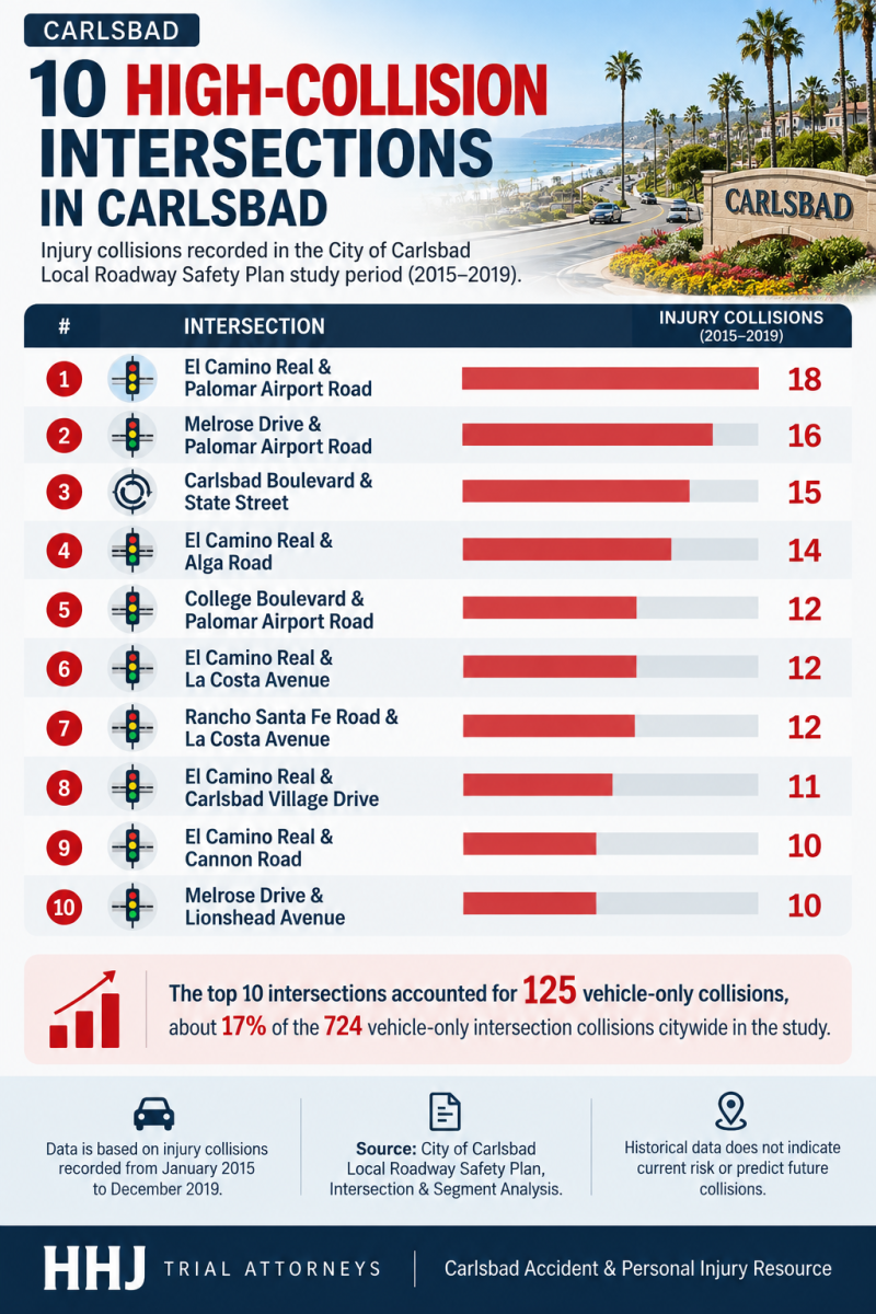
The map also highlights intersections identified in the City of Carlsbad’s historical roadway-safety analysis.
Rather than labeling individual locations as inherently “dangerous,” the map is designed to provide context around historical collision patterns and the city’s transportation network.
Several Major Carlsbad Corridors Appear Throughout the Data
One notable feature of the historical collision information is the repeated appearance of several major roads.
El Camino Real, for example, intersects with Palomar Airport Road, Alga Road, La Costa Avenue, Carlsbad Village Drive and Cannon Road — locations that appeared prominently in the city’s historical intersection analysis.
Palomar Airport Road is another important east-west corridor connecting Interstate 5 with employment centers, businesses and residential areas farther inland.
Carlsbad Boulevard presents a different transportation environment. Running along the coast, it serves motorists as well as pedestrians and cyclists traveling between beaches, neighborhoods and Carlsbad Village.
Understanding these differences can help residents recognize why road safety cannot be viewed solely through citywide statistics.
More Than an Accident Map
The new resource goes beyond displaying intersections.
It also identifies major community destinations and emergency or medical resources around Carlsbad, creating a broader reference point for residents and visitors.
Users can explore the Carlsbad Personal Injury & Accident Resource Map to see these locations and better understand how they fit into the city’s transportation network.
An accompanying interactive geographic map is also available through BatchGeo:
https://batchgeo.com/map/carlsbad-accident-map
Using Historical Data Responsibly
Historical collision information provides insight into where incidents occurred during a particular study period, but it should not be interpreted as a prediction of where future crashes will happen.
Road conditions, traffic volumes, infrastructure and safety improvements can change over time.
The value of tools like this lies in making public information more accessible and encouraging drivers, pedestrians and cyclists to remain aware of their surroundings.
For a growing coastal city such as Carlsbad, accessible local transportation information can help residents better understand the streets they use every day.
About HHJ Trial Attorneys
HHJ Trial Attorneys serves individuals and families throughout Carlsbad and San Diego County. The firm’s Carlsbad office is located at:
Interactive Carlsbad Map: View the Carlsbad Accident Map
Media Contact:
Company Name: HHJ Trial Attorneys: Car Accident & Injury Lawyers
Address: 2175 Salk Ave Ste 180,
City: Carlsbad
State: CA
ZIP Code: 92008
Country: United States
Phone: +1 760-444-0275
Website URL – https://hhjtrialattorneys.com/carlsbad-personal-injury-lawyer/
Social Media:
https://www.facebook.com/767566010105041
https://www.tiktok.com/@hhjtrialattorneys
https://www.instagram.com/hhjtrialattorneys/
https://www.youtube.com/@619injured